The boundaries of Garff Sheading have ebbed and flowed for centuries: the original Sheading comprised Maughold (inc. South Ramsey), Lonan (inc. Laxey), and Onchan.
In 1796 an Act of Tynwald transferred Onchan to Middle Sheading and in 2013 a further Act of Tynwald returned part of the Howstrake area to the Gar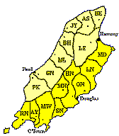 ff Tynwald constituency (Click on the image on the ‘Manx Parishes’ link for more information).
The Local Authority boundaries have remained intact apart from the recent internal amalgamation of Laxey, Lonan and Maughold; the Garff Commissioners’ local authority boundary now forms the largest local authority in terms of geographical area as well as having one of the largest populations.
Interestingly, the division of the Island into two sectors post Godred Crovan’s time designated Maughold as in the south (see section highlighted in yellow in the image) as it fell below the mountain ridge line that culminates in North Barrule. From then on the parish was firmly embedded into Garff Sheading.